Advertisement
Advertisement
Science
Get more with myNEWS
A personalised news feed of stories that matter to you
Learn more
A continuous boundary in the South China Sea being drawn by Chinese government scientists will be based partly on a map approved and published by Beijing in 1951. Photo: HANDOUT

China’s claims in South China Sea ‘proposed by continuous boundary for the first time’

Joining of the nine-dash line by scientists is based partly on 1951 map that ‘furthers the certainty of China’s seas’
Science

Researchers are proposing a new boundary in the South China Sea that they say will help the study of natural science while potentially adding weight to China’s claims over the disputed waters, according to a senior scientist involved in the government-funded project. 

The new boundary will help to define more clearly China’s claims in the contested region, but it is not clear whether or when it will be officially adopted by Beijing, the scientist said. 

A precise continuous line will split the Gulf of Tonkin between China and Vietnam, go south into waters claimed by Malaysia, take a U-turn to the north along the west coast of the Philippines and finish at the southeast of Taiwan.

For decades, China’s sovereign claim in the South China Sea has been murky, in large part because of the use of a segmented, vaguely located borderline known as the ‘nine-dash line’.

A United Nations tribunal ruled in July 2016 that China had no legal basis to claim the area within the dash lines. One reason for China losing the case was that it could not define the territory precisely.

However, analysts said Beijing was unlikely to officially change the nine-dash line any time soon, in the face of potential international opposition. 

Changing the nine-dash line could harm regional stability, warned Dr Ian J. Storey, senior fellow with Yusof Ishak Institute in Singapore studying maritime security in the Asia-Pacific and Southeast Asia’s relations with China.

“If China does indicate its claims in the South China Sea by a continuous line which joins up the nine dashes, it would represent a complete repudiation of the July 2016 arbitral tribunal ruling,” Storey said.

The move would “cause deep concern in the capitals of Southeast Asia and beyond”, he added.

The Chinese foreign ministry did not respond to requests for comment. 

The vast area of blue outlined by the new boundary, hanging on a map like a Christmas stocking under South China, overlaps the dashes and fills in the gaps. It includes all contested waters, such as the Paracel Islands, the Spratly Islands, James Shoal and Scarborough Shoal. 

The boundary would determine for the first time the exact area that China claimed to own with historic rights in the South China Sea, according to the researcher.

Its purpose was partly the study of natural science and partly driven by a political motivation “to strengthen China’s claims” over the waters to prepare for possible changes in its South China Sea policy in the future, the researcher said.

Within the boundary, China would claim the right to activities ranging from fishing, prospecting and mining for energy or mineral resources to the construction of military bases with deep water ports or airports. 

Other countries’ access to these rights would, however, be open for discussion, as is the case at Scarborough Shoal, which China controls but allows Philippine fishing boats to access.

While Beijing would consider the area within the boundary its territory, other countries would still have freedom of navigation, the researcher said. 

The project team had pinned down the initial location of the boundary using global satellite positioning. 

“The GPS data set is ready,” said the researcher, who requested not to be named because of the sensitivity of the study. “It can provide different resolutions, from a kilometre to a few centimetres [regarding the width of the line], depending on the need in practice.”

An airstrip and buildings on China's man-made Subi Reef in the Spratly Islands. Photo: AP
Drawing the boundary was just the first step, the researcher said. Calculations of the total biomass, oil and gas reserves, mineral deposits and other natural resources in the China-claimed area were also under way, with funding from the Chinese central government and provincial authorities of Guangdong.

Although the Chinese claims are based on historic record, part of the research is to determine the value of China’s assets within the boundary. 

“Soon we will have a clear idea of what belongs to us in the South China Sea and what does not,” said the researcher. “This will allow us to better plan and coordinate the efforts to protect our national interest in the region while reducing the risk of conflict with other countries caused by the absence of a border over the ocean.”

The nationalist government first adopted the dash drawings in 1947, when officials inspected the South China Sea on a US naval ship before drawing the dashes on their return. 

The dash drawing – short curves loosely located in the ocean with vast bodies of undefined water in between – was to give a general but imprecise impression of Chinese sovereignty in the region while acknowledging freedom of navigation for vessels from other countries.

At first there were 11 dashes, but in the 1950s the Chinese government removed two dashes in the Gulf of Tonkin to please the communist rulers in Vietnam. In 2013, Beijing added a dash southeast of Taiwan, bringing the total to 10.

Beijing is a signatory of the United Nations Convention on the Law of the Sea (UNCLOS), an international agreement that defines the rights and responsibilities of nations with respect to their use of the world’s oceans, and establishes guidelines for businesses, the environment and the management of marine natural resources.

But it has intentionally never ­defined the legal meaning of the nine-dash line or what its rights are within the boundary. This ambiguity has led many in China to believe that it marks the nation’s maritime boundary, but, again, Beijing has never made this explicit. 

Others say it encircles the area where China demands economic rights. Another interpretation is that the line indicates the islands and reefs China wants to control rather than the waters inside its boundaries. ­Beijing has long favoured a strategy of ambiguity, not openly acting against international law but preferring to leave space for its more ambitious claims.

In recent years, China has launched a massive campaign to expand and strengthen its grip in the South China Sea, with giant dredging ships turning small islets into man-made islands with military radar stations and air strips, oil drilling platforms being deployed in contested waters, and regular large-scale naval exercises involving aircraft carriers, advanced warships and nuclear submarines.

Some scientists believed that the total number of undersea surveillance sensors deployed by China in the South China Sea had already exceeded those by the US, a sign of shifting balance in the region.

“More often, when we are sending vessels out to the sea or looking down at an area via satellite, we are not sure whether it was our water,” said the researcher in the boundary-drawing project.

“The nine-dash line can no longer meet the demands of increasing Chinese activities in the South China Sea.”

“There is no way to calculate how large an area is by drawing the border with dash lines,” said Professor Zou Jingui, deputy director of the School of Geodesy and Geomatics at Wuhan University. “You have to give a computer a closed boundary. Replacing the nine-dash line with a precise, continuous boundary will make work in this area easier.” Zou was not involved in the project.

The continuous boundary was generated not only by curve-extending, gap-filling algorithms on computer. It was also based on a solid piece of historic evidence, according to the project team. 

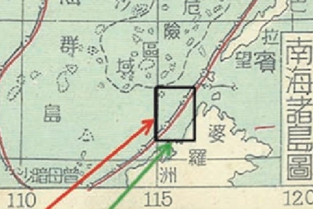
In 1951, an official map approved by the central government of China marked the China-claimed area in the South China Sea with a pair of non-stopping lines. There was an inner black line indicating the sovereign boundary and an outer red line representing where China could exercise administrative power.

A continuous boundary in the South China Sea being drawn by Chinese government scientists will be based partly on a map approved and published by Beijing in 1951. Photo: HANDOUT

“We were thrilled when we found the map,” the researcher said. “It is something we can show the world.” 

A detailed description of the map was published by the project team in a paper in domestic academic journal China Science Bulletin in March this year.

Its authors recommended using the continuous U-shape boundary line as a replacement for the nine-dash line.

The “U-boundary is the border of China’s sea in the South China Sea, and its sovereignty belongs to China”, the authors wrote in the paper.

It “can further express the certainty of the integrity, continuity and border of China’s seas in the South China Sea”, they wrote, adding that it was “more vivid, accurate, complete and scientific”.

Professor Yu Minyou, director of the China Institute of Boundary and Ocean Studies at Wuhan University, said that if the old map was published with government approval, which was usually the case in China, “it surely will add legal weight to China’s claim” in the region. 

A scientific basis for estimating natural resources was important to China, otherwise it would have nothing concrete or precise to put on table when negotiating with its neighbours, he said. 

But other countries should bear in mind that it did not represent the Chinese government’s position as long as the dash lines stayed on official maps, Yu said, adding that China’s strategy for the South China Sea was “open and clear”. 

“China wants to achieve peace, stability, harmony and prosperity in the region,” he said. “We are willing to share natural resources with other countries and leave the disputes to be solved in the future. 

“What we are doing now is creating a suitable environment for the final settlement of the issue.”

A Chinese naval exercise near the James Shoal. Photo: AFP

A government expert at the National Institute for South China Sea Studies in Haikou, Hainan, said the continuous boundary would serve as a useful tool for some studies of natural science.

But it was highly unlikely to be printed on an official map, said the expert, who requested not to be named because he was not allowed to speak to overseas media about sensitive issues.

“To my knowledge, the Chinese government currently has no plan to change the dash lines,” he said. “Most diplomats and ocean law experts will oppose joining the dashes.”

The tension in the South China Sea has eased significantly in recent times, with neighbouring countries such as the Philippines and Vietnam no longer seeking direct confrontation with China over disputed areas.

“Things are moving towards the right direction,” the government expert said. “It is not the best time to cut a boundary.”

This article appeared in the South China Morning Post print edition as: New Boundary ‘defines ocean claims’ by China
Post