Advertisement
Advertisement
Typhoon Hato
Get more with myNEWS
A personalised news feed of stories that matter to you
Learn more
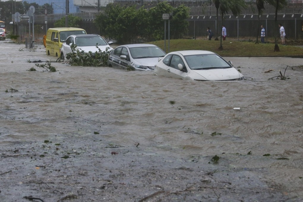
Flood and debris around Heng Fa Chuen in Chai Wan as Typhoon Hato hits Hong Kong. Photo: Sam Tsang

Typhoon Hato causes delayed flights and heavy flooding in Hong Kong

Hundreds of flights cancelled, ferry services suspended and flood warning in place for only the 15th No 10 storm since 1946

Typhoon Hato

A typhoon signal No 10 – the highest in Hong Kong’s storm warning system – was issued on Wednesday morning, before being downgraded first to No 8, then No 3 as Typhoon Hato wreaked havoc on the city.

It was only the 15th No 10 signal since 1946, the last coming in July 2012, for Typhoon Vicente.

The Observatory issued the signal at 9.10am. At 8am it issued an amber rainstorm warning, which means more than 30mm of rain is expected to fall within an hour.
As the storm approached overnight, businesses, public services, airlines and public transport all braced for what could be one of the worst storms in recent years.

“Tides are currently running about 0.5 metres above normal,” the Observatory said in its 6.45am storm update.

“The high tide, occurring before noon, and the storm surge induced by Hato may cause a rise in sea levels of about 1 metre or more above normal tide levels. There could be serious flooding in some low-lying areas.”

The storm will be closest to the city on Wednesday afternoon, coming within 100km to the west of Hong Kong, before making landfall in neighbouring Guangdong province.

The MTR suspended services on outdoor lines. Trains continued running, at 15-minute intervals, between underground stations, mainly in urban areas.

All Airport Express services between Central and Hong Kong International Airport were suspended.

Blast from the past: deadly typhoons in Hong Kong

Hato, named after the ­Japanese word for pigeon, packed enough of a punch for China’s national weather authorities to issue their second highest alert for rainstorms and warn of downpours hitting the region.

Airlines on Tuesday warned of “severe” cancellations and ­delays on Wednesday that could turn out to be the worst disruptions since Hong Kong International Airport opened nearly two decades ago.

The Airport Authority advised travellers to contact their airlines before going to the airport.

At least 320 flights operated by Cathay Pacific Airways, Cathay Dragon and Hong Kong Airlines, scheduled to take off or land between 6am and 5pm on Wednesday, were cancelled.

Almost all daytime bus services operated by KMB, New World First Bus and Citybus were suspended.

The Education Bureau announced schools would be closed on Wednesday.

Strong waves hit Lei Yue Mun. Photo: Sam Tsang

First Ferry, which serves the outlying islands, suspended ferry services “until further notice”.

All ferries to and from Macau were also called off.

At 6.30am, Quarry Bay tide levels had risen by 2.37 metres. That was faster than the 1.8 metres predicted for the same time.

Near Tseung Kwan O – at Tai Miu Wan – tides jumped 2.52 metres, exceeding the predicted peak of the tide of 2.3 metres due at 10am. One area being closely monitored was the low-lying fishing village of Tai O, which is regularly threatened by rising waters.

Hong Kong Exchange and Clearing cancelled pre-market trading and said the start of trading on securities and derivatives markets would be delayed because of the typhoon.

It said if the signal was still above 8 at 9am then morning trading would be cancelled. The same would apply to afternoon trading after midday.

That put the Hong Kong stock exchange, the world’s fourth largest equity market according to Bloomberg, on track to be closed for the entire day. The exchange was previously closed all day for typhoons Haima and Nida in 2016.

Post