US man asks Google Maps to remove aerial image of murdered son
A California man wants Google Maps to remove an aerial image that shows the body of his 14-year-old son, who was shot and killed in 2009.
Jose Barrera told KTVU-TV that he became aware of the image of his son Kevlast week. He said he wants Google to take down the image out of respect for his son, but it wasn't clear whether he had made a direct request to Google to remove it.
"When I see this image, that's still like that happened yesterday," Barrera told the news station on Sunday. "And that brings me back to a lot of memories."
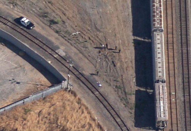
The image shows what appears to be a body on the ground near a rail line with several other people, presumably investigators, and what looks like a police car nearby. It was visible on Google's website Monday.
Kevin's body was found on a path near railway tracks that separate North Richmond in California from San Pablo on August 15, 2009. His slaying remains unsolved. Police believe Kevin was killed in the same spot the night before his body was found, said Richmond police Sergeant Nicole Abetkov. They have not established a motive for the slaying or identified any suspects.
An e-mail to Google was not immediately returned. The company says most of its overhead images are about one to three years old, although it tries to update them regularly.
Google Maps also provides a street view function that allows people to tour areas as someone passing through them would. Street View displays images that have been gathered by Google using cameras mounted on cars, tricycles and even snowmobiles.
Some of the images have raised privacy concerns, though Google says its technology automatically blurs licence plates and people's faces. Users can also report concerns about images.
There is, however, no similar reporting feature for overhead imagery, according to Google.