Highest mountain in Southeast Asia, Mount Kinabalu rewards trekkers with spectacular views and region’s highest loos
- Two-day trek takes hikers up through the lush jungles of Sabah in Borneo to the volcanic rock expanses of 4,095-metre peak’s upper slopes
- Climbers can admire the beauty of the predawn skies over the summit, then take an adrenaline-sapping circuit of the peak before descending well-equipped trail

“Grab the rope,” commands my guide, as I take a deep breath and pull on my gloves after adjusting my head torch. It is not every day you are asked to scramble up what looks like a 45-degree rock cliff at 4am. And we have not even reached the via ferrata, an assisted climbing route on the steepest part of our climb.
We are ascending Mount Kinabalu in Malaysian Borneo, the highest mountain in the country, and the highest in Southeast Asia outside the Himalayan range.
There are two legends relating to its name. One says it comes from Aki Nabalu in the indigenous Kadazan-Dusun culture, whose people believe the mountain is where the spirits of their ancestors go after death.
The other is the story of a Chinese prince who defeated a dragon atop the mountain and married a local woman, but eventually returned to his parents in China in the 15th century. His wife waited for him on the peak and turned to stone – now St John’s Peak – earning the name Cina Balu, Chinese widow.

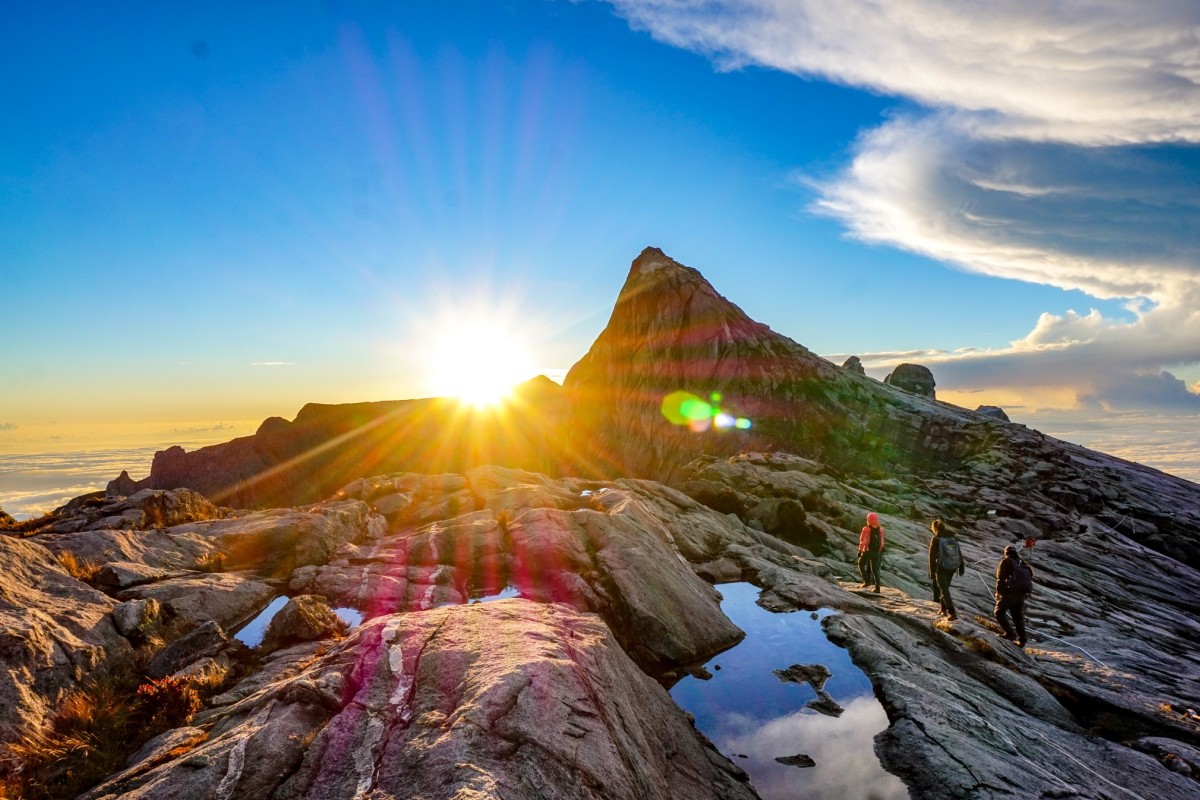
Mount Kinabalu rises to 4,095 metres (13,435 feet) above sea level and the summit trail is well furnished with facilities such as bathrooms and resting pavilions along the way. Most of the trail goes through lush Borneo jungle, with the last 2.5km (1.5 miles) a batholith of granite diorite, an igneous intrusion of cooled magma from a volcanic eruption that formed 10 million years ago.
It is now mandatory for hikers to break their climb to the summit into two days, with an overnight stop, to avoid people underestimating its difficulty and injuring themselves.

Hikers stay overnight at Panalaban Base Camp, at 3,272 metres (10,735 feet) above sea level. A 6.0 magnitude earthquake in 2015 destroyed much of the accommodation. The newly reopened huts offer luxurious amenities considering the location. Showers and running water are available, as are beds with proper pillows and duvets.
As a rule, climbing to the summit and back down again takes 32 hours; hikers make their way up to Panalaban Base Camp on day one, then reach the summit on day two and descend.
We start our hike at 9.30am, meeting our mountain guide at Kinabalu Park, where we are transferred to Timpohon Gate via minivans.

The first day is comparatively easy, with the 6km (3.7 mile) hike taking about six hours to complete. The starting point is 1,866 metres above sea level, so some 1,400 metres of vertical ascent is involved; we climb what seems to be an endless flight of stairs through the jungle.
Shrouded in afternoon mist, the hike is somewhat monotonous, our only distractions being the hikers on the way down wishing us luck, the wild nepenthes (a carnivorous plant) along the way, and the sign telling hikers they have only a further 500 metres to go until base camp.

The next morning is the climax of our trip: the three-hour trek from Panalaban to the top of Mount Kinabalu. The summit climb starts at 2.30am, but we wake earlier for an energy-boosting breakfast. It is a battle of will to hobble up the unrelenting stairs in the dark and cold, but these finally give way to a smooth expanse of rock. A white rope marks the main trail to ensure we do not get lost.
‘If hell were a mountain, it would look like Mount Kinabalu’
The last checkpoint appears just after we climb a particularly steep section – we use the rope to help us up. It marks the final 1.5km to the peak, and it is also where you can find the highest bathroom in Southeast Asia, at 3,700 metres above sea level. We had to reach this checkpoint before 5.30am otherwise we would not be allowed to summit because of time constraints: we need to leave time to hike back down to base camp and retrace our steps on the 6km trail we covered on day one.

The last stretch feels long, but we are rewarded with a view of predawn colours across the sky as we clamber our way up to the top of the peak. It takes some manoeuvring to secure a spot on the edge of a fence to watch the sunrise, as hikers congregate on the small peak. The rising sun spreads across Mount Kinabalu, its warm glow transforming it from a dark hell of endless inclines to a land straight out of legend.
We did not stay long to enjoy the view, however, in order to make it to the via ferrata – two assisted climbing routes that feature steel cables fixed to the rock, ladders, suspension bridges and zip wires. The Low’s Peak Circuit is the highest such walkway in the world, and Walk the Torq is a shorter alternative.
The Low’s Peak Circuit is perfect for adrenaline junkies and on average takes four hours. I overcome my fear of heights and cross a five-metre tightrope over a canyon before pulling myself up a 10-metre-long hanging ladder. While the Walk the Torq route is less dramatic – no cliff walk or suspension bridge here – it is a good choice since the summit climb takes a lot of energy.

Getting there
Most tour companies offer transfers to and from Kota Kinabalu. To get to Mount Kinabalu on your own, there are buses and shared taxis from the Padang Merdeka Bus Terminal in Kota Kinabalu.
Before you go
Hiking slots open three months in advance on the official website (mountkinabalu.com), with last minute deals occasionally available; however, you can book even earlier with tour companies. The trek is cheaper for Malaysians, as they pay a reduced permit fee. A guide is compulsory for foreign hikers, and porters are available for hire.

When to go
Mount Kinabalu can be hiked year round; however, avoiding the wet season between October to January is best since summit climbs can be cancelled in the event of of bad weather. While it often rains on the way up, the sky tends to open up during the early morning hours with a rewarding sunrise, before the clouds settle in again. The driest season is from February to April.
