Advertisement
Advertisement
South China Sea
Get more with myNEWS
A personalised news feed of stories that matter to you
Learn more
Four new tetrahedral structures can be seen clearly on Taiping Island from the latest Google Earth map. Photo: SCMP Pictures

Taiwan’s new facilities on Taiping Island may have military use

Outpost is part of the Spratly Islands and is also claimed by mainland China, the Philippines and Vietnam.
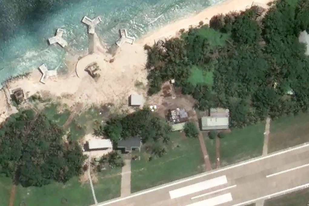
Taiwan is building four concrete structures on the disputed ­Taiping Island in the South China Sea, in what might be a facility to increase its military alertness.

The structures, about three to four storeys high, were found to have been built on the coastline of the west side of Taiping surrounding a circular structure still under construction on the shore, ­according to a recent Google Earth map.

Taiping is part of the Spratly Islands and is also claimed by mainland China, the Philippines and Vietnam.

The discover of the facilities comes at a sensitive time when both Taiwan and the mainland are protesting against a ruling by an international tribunal over the status of the South China Sea ­archipelagoes.

They were not there on the previous map taken by satellite in January last year.

Taiwanese Defence Minister Feng Shih-kuan on Tuesday ­declined to reveal what exactly the structures were for.

“It is inconvenient for us to ­reveal any military facilities we are installing on Taiping Island and what their purposes are as they are all considered secrets,” Feng told reporters after a legislative session in Taipei. But he assured the public that “Taiping Island has strong defensive capability.”

According to Kuomintang legislator Johnny Chiang Chi-chen, the structures were there in July when he led a group of lawmakers on a trip to Taiping to assert ­Taiwan’s ownership claim and protest over the ruling.

The tribunal ruled Taiping was a rock and therefore could not be used to justify claims in the surrounding waters under the United Nations Convention on the Law of the Sea.

Taiwanese media have speculated the structures could house anti-aircraft weapons.

Military experts said they could be used to launch mobile surface-to-air missiles but they were more likely devoted to detection and surveillance.

“It is unlikely a cannon base, given that the salty waters and ­vapours would rust the cannons,” military expert Chen Kuo-ming said.

“Very possibly they are for a certain kind of military alert ­system or facility that can be mounted on them,” Chen said.

Arthur Ding, an associate ­research fellow at Stockholm-based Institute for Security and Development Policy, said the construction would have been approved by former president Ma Ying-jeou to increase Taiping’s defences amid the dispute over the South China Sea.

“Sensitive as they may be, I don’t think it would greatly escalate the tension in the region, given that Taiping is controlled by Taiwan, which is considered relatively moderate over the South China Sea dispute,” he said.

Meanwhile, legislators have demanded that the defence ministry and Taiwan’s Coast Guard Administration contact Google and ensure the company ­obscures details of the structures in their photos to protect Taiwanese military secrets.

Macau-based military expert Antony Wong Dong said the four structures appeared to be large coastal forts to prevent any landing assaults.

A previous map (left) compared with the latest Google Earth map on the right, with the new structures. Photo: SCMP Pictures

“The surrounding area ... is the most suitable landing beach on Taiping. Such kinds of construction were only found in Germany during the second world war and Taiwan,” Wong said.

“The coastal forts can effectively stop vessels from Vietnam or even deter mainland warships from landing on Taiping.”

Wong said the structures might be equipped with heavy machine guns, howitzers or even anti-tank weapons.

Additional reporting by Minnie Chan

This article appeared in the South China Morning Post print edition as: Taiwan adds to military facilities on Taiping Island
Post