
Nimble Chinese satellite grabs hi-res images of US city in seconds: researchers
- The Beijing-3 small commercial satellite can take images while rotating at up to 10 degrees per second, a speed not seen on a satellite before: paper
- Coupled with AI on board, the satellite can monitor up to 500 areas of interest around the globe with nearly 100 revisits a day

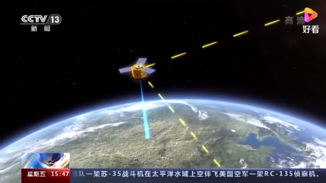
In just 42 seconds, a small Chinese satellite captured images of a large area around a US city that would be sharp enough to identify a military vehicle on the street and tell what type of weapon it might be carrying, say scientists reporting on the breakthrough.
Most Earth observation satellites must be stable when taking images because attitude control mechanisms can produce vibrations that blur the images. But in this experiment on June 16, the Beijing-3 rolled and yawed wildly, the dramatic motion changing the angle of its camera’s line of sight to the ground when flying over North America. The movement allowed it to capture a larger area than satellites have managed until now.
01:30
China’s nimble Beijing-3 satellite does unprecedented rapid scan of San Francisco
The image, taken from an altitude of 500 kilometres (310 miles), had a resolution of 50 centimetres per pixel. The performance test over North America and other areas showed that the satellite could take images while its body was twisting at up to 10 degrees per second, a speed not seen on a satellite before.
“China started relatively late on agile satellite technology, but achieved a large number of breakthroughs in a short period of time,” said project lead scientist Yang Fang and her colleagues of the DFH Satellite Company writing in a paper published in the domestic peer-reviewed journal Spacecraft Engineering this month. “The level of our technology has reached a world leading position.”
Despite its small size and relatively low cost, Beijing-3 was deemed as the most nimble satellite and could be one of the most powerful Earth observation satellites ever built, according to Yang.
China’s power grid is world’s biggest – and now protected by quantum satellite
A satellite in the lower orbit could usually observe a straight, narrow strip of area underneath it. It must circle the Earth multiple times or work with other satellites to cover a region of interest.

With artificial intelligence technology on board, the satellite could plan its flight schedule independently to monitor up to 500 areas of interest around the globe with nearly 100 revisits a day.
The satellite could also detect the presence of certain targets and send their targeted photos to ground control.
Beijing-3’s response time is 2-3 times faster than that of WorldView-4, the most advanced earth observation satellite developed by the United States with similar technology, according to Yang and colleagues.
Compared to WorldView-4, Beijing-3’s scanning band is 77 per cent wider (the Chinese satellite’s 23km compared with the American satellite’s 13km) at only half the weight.
However, the US satellite has a marginal lead in an area vital for some sensitive applications.
01:03
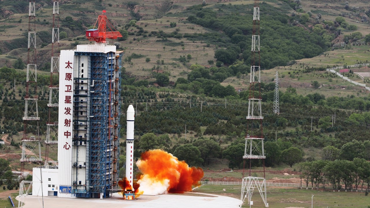
China launches Long March 2D rocket carrying Beijing-3 and three other satellites
WorldView-4’s one-metre-wide telescope could produce slightly more detailed images with a resolution of 30 centimetres per pixel. Although not sharp enough to read a car number plate, this resolution could reveal a military vehicle’s make and model to help estimate its performance, such as firing range.
But its overall performance may not be a match for Beijing-3, according to Yang.
When adjusting its position, WorldView-4 could experience vibrations, reducing image quality at the finest level.
The Chinese team said they had used a new technology to reduce vibration by an order of magnitude, even when the satellite was rotating and pitching at record speed.
The WorldView-4 satellite was built by Lockheed Martin for more than $US800 million. Launched in 2016, the satellite was expected to operate for 10-12 years to provide the finest images from space that money could buy.
It failed unexpectedly in 2019 because of a glitch in an attitude-control gyroscope.
Yang and her co-authors said the Beijing-3 satellite was built on a revolutionary platform known as CAST3000E that would give rise to a new generation of Chinese observation satellites that were small in size but high in performance.
The new platform carried solar panels with a unique structure to stop them shaking as the satellite turned quickly and sharply. An advanced cooling system could prevent overheating of any components suddenly exposed to the sun.
Critical components, such as telescopes and antennas, were also designed using new technologies, such as AI control, to protect the satellite from the physical toll caused by rapid movement.
A satellite built on the new platform could store one terabyte of images and beam data to the ground at the speed of one gigabyte per second, outperforming competing satellites from the US.
05:06
How China’s space programme went from launching satellites to building its own space station
Although China had caught up with technology, the global earth observation market was still dominated by the West, said Qi Yimin, a sales manager for DFH Satellite Company in Beijing.
In China, more than 85 per cent of the high-definition satellite imaging products and nearly all low-to-medium resolution products were now produced by Chinese satellites, Qi said in a separate paper published in the same journal this month.
These images were used by more than 20,000 Chinese companies and generated over 260 billion yuan (US$41 billion) in annual revenue.
China launches its first sun satellite to monitor solar eruptions
But only a small number of countries – such as Egypt, India and the Netherlands – had bought commercial satellite images from China, Qi said.
“Our country’s commercial satellites started late, the industrial chain is not yet mature, and the business is still in the initial stage of development,” Qi said in the paper.
Most Chinese satellite imaging products served government or military users.
“We will need to change our business model to develop other potential customers,” he added.
