Advertisement
Advertisement
Urban planning
Get more with myNEWS
A personalised news feed of stories that matter to you
Learn more
Rico Tsang (left), senior town planner, and Silas Liu, chief town planner, hope the new 3D system will fast-track their work. Photo: Felix Wong

New 3D mapping system with one-stop data source allows Hong Kong planners to build urban sites SimCity style

  • Biggest implication of lauded technology is ability to cater to needs of greying population
  • System comes with plans to make geospatial data accessible to public for app developers and professional bodies as part of smart city push

A new 3D-mapping system has allowed Hong Kong authorities to plan and visualise the dense urban environment in a faster and easier way, much like in the computer game SimCity.

The 3D Planning and Design System, which was rolled out in February and won an award from the Institute of Planners in November, allows officials to generate digital simulations of proposed structures on a 3D map.

The tool caters to the needs of a greying population amid a rising demand for urban redevelopment. Before the roll-out of the system, planners had to spend days on different platforms and software generating assessments for a multitude of urban environmental issues.
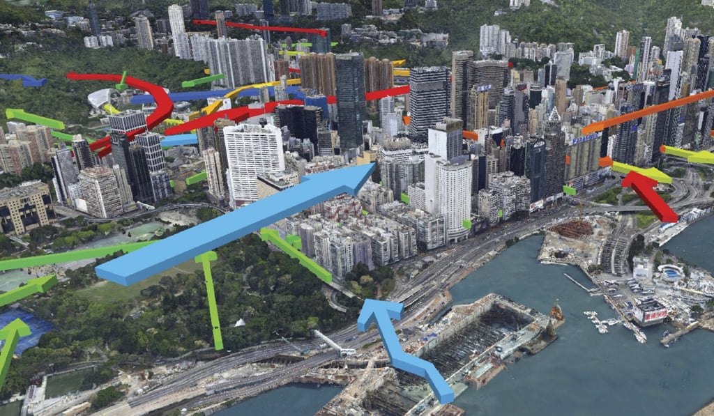
A screen capture of the 3D Planning and Design System showing air flows. Photo: Handout

The system’s biggest advantage is that it acts as a one-stop portal, embedded with all kinds of data ranging from population trends to building heights. Such information allows preliminary analyses of how a proposed building will impact the neighbouring environment, with assessments of air ventilation and even whether it would affect the view of neighbouring blocks.

Is Singapore’s model the answer to Hong Kong’s urban planning problems?

“As a planner, drawing a proposed building is easy. What’s difficult and most time consuming is figuring out how the proposed building will affect its neighbouring environment,” chief town planner Silas Liu Kam-ming said.

What’s difficult and most time consuming is figuring out how the proposed building will affect its neighbouring environment
Silas Liu, chief town planner

Aside from fast-tracking the planning process, the upgrade also paves the way for authorities to plan for an ageing population.

Liu cited an example of creating open space in Wan Chai.

“With one click on an area in Wan Chai, it also shows us other socio-economic data. The statistics show that the overall population here will drop to 150,000 from the current 180,000 in 10 years’ time, but if you look at those over 65, it actually increases from 29,000 to 37,000 in the same period,” Liu said.

“So the government could think about building a lawn bowling field instead of a soccer pitch for retirees, for example,” he said.

The system won a Certificate of Merit from the Hong Kong Institute of Planners in November.

By 2046, some 326,000 private sector flats will be over the age of 70. This will be 300 times more than the situation today, according to the government’s planning blueprint.

Old private flats will be concentrated in urban areas, such as Yau Tsim Mong district.

The system allows comparisons of variations of a proposed building plan. Photo: Handout

The Planning Department is expected to also make the 3D map and its interrelated geospatial data public so it can be used by app developers or professional bodies by the end of this month.

It would start with a small section of Central as a trial area and gradually release data covering most of Hong Kong Island and Kowloon next year, as part of the government’s ongoing efforts to promote open data and smart city planning.

Government ‘exaggerated constraints’ in freeing up brownfield sites

Separately, the Lands Department is also expected to open up more geospatial data to facilitate smart city development.

The recently revamped GeoInfo Map provides public access to information concerning about 270 types of public amenities, such as locations of free Wi-fi hotspots and real-time traffic and air quality data.

The department plans to free up other land-related data such as the locations of vacant government sites available for application for community use and public open spaces in private developments.

Post