
Monsignor Volontieri's map of Sun On. Picture: National Library of Australia
Early maps of Hong Kong, however inaccurate, provide a picture of its historical evolution and ever-shifting borders. writes Jason Wordie
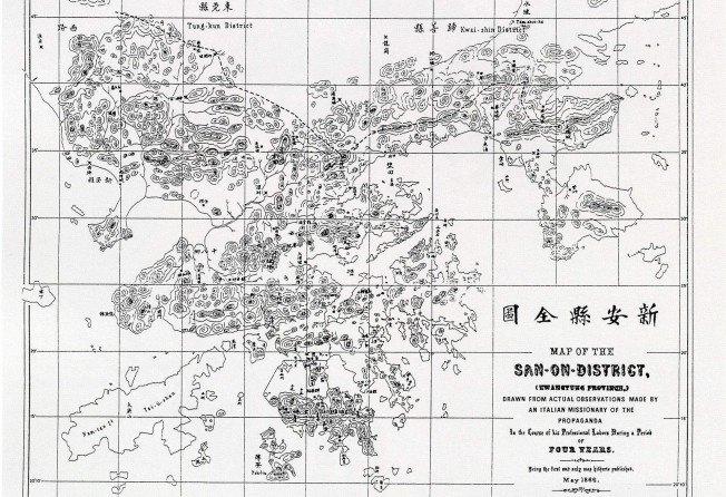
Monsignor Volontieri's map of Sun On. Picture: National Library of Australia
For such a relatively small place, Hong Kong has been extensively
- some might say exhaustively - studied and documented. And in few instances has this documentation been more thorough than in mapping.
Recent controversies about perceived redefinitions of the northern border with the mainland are nothing new. Hong Kong's boundaries with Guangdong - call these arbitrary lines on a map, if you will - have always been somewhat fluid, subject to change as political and economic circumstances dictated.
For centuries, Hong Kong formed part of Po On county, which was also known as Sun On county. As the region was remote, and, like much of the area south of the Shenzhen River, sparsely populated and mountainous, detailed maps were rare and held only by the provincial administration.
Early Chinese maps, found in gazetteers prepared or updated by outgoing magistrates for their replacements, generally dealt with crops, natural resources and who owned what. Streams, hillside contours and coastlines were not considered very important.
British-era maps from the 1840s show depth soundings in the waters around Hong Kong Island - essential for ships in the days before modern piers and other wharf facilities. Other navigational hazards, such as rocks, reefs and shoals, were marked. Many have long since disappeared - either removed or smothered by reclamation.
The first accurate Western-style map of Po On county/Sun On district was drawn in 1866 by one Monsignor Volontieri, an Italian missionary priest who worked among Hakka communities in the East River districts in Guangdong. His map details the many inter-village trails that now form either hiking routes or the foundations of modern roads.
When the Convention of Peking was signed in 1898, which leased the New Territories to Britain for 99 years, Volontieri's effort - minor inaccuracies and all - was used to delineate the new international border. Some of these minor flaws became major problems: for example, the border at Sha Tau Kok ran down the middle of the village's main street.
The New Territories were accurately mapped by a British Army Royal Engineers team brought in from India, between 1899 and 1902. During this survey, rivers, ranges and other natural features were detailed and renamed. Mountain ranges and uplands across the northern New Territories were designated the Chilterns, Cotswolds and South Downs after similar-looking locations in England (most have now reverted to their Chinese names).
Streams were named after major rivers in India, such as the Indus, Ganges and Beas. Only the latter has continued in use; the Hong Kong Jockey Club maintains a country club at Beas River.
Various grandly named, vaguely equestrian-sounding property developments dotting that area also use Beas River in their promotional literature, presumably to let one believe these "prestigious" villas are not actually in Sheung Shui.
Aerial surveys were conducted in the early 1920s from the newly established Royal Air Force Station at Kai Tak. Intermittently updated in following decades, these photographs, along with publicly available maps, help reveal the extent to which land has been reclaimed and shorelines have shifted in the years since.