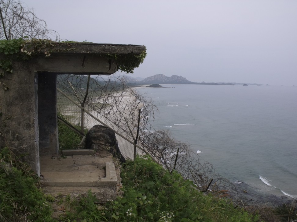
The coastline along the demilitarised zone. Photo: Julian Ryall

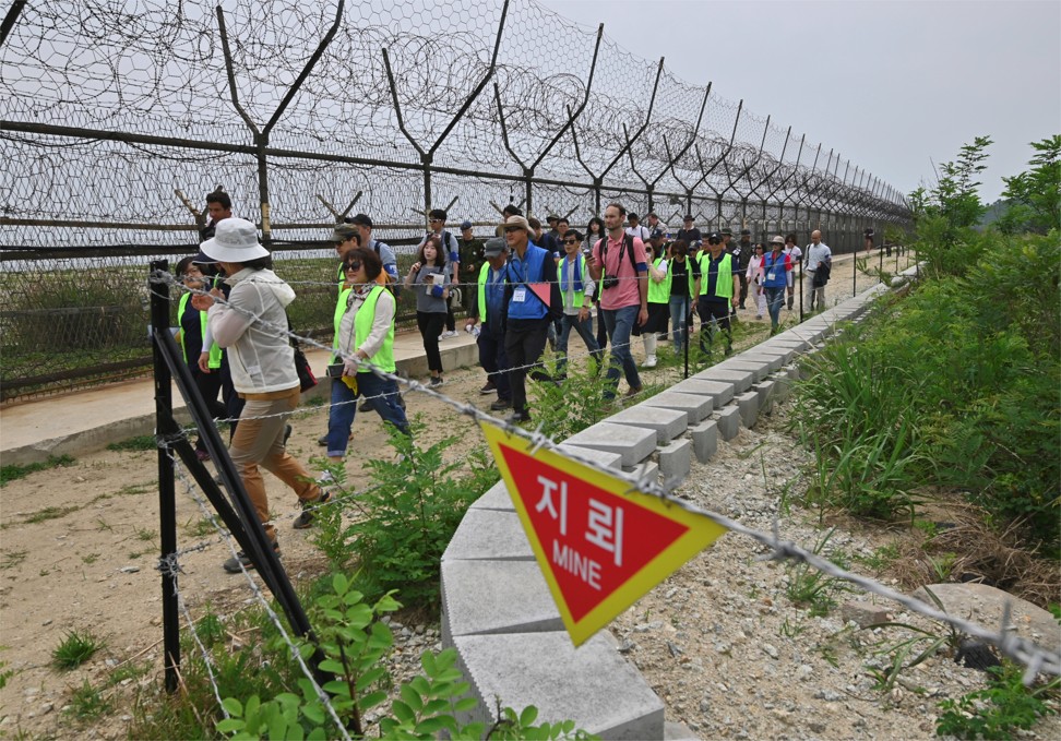
The deer raises its head and, still chewing and flicking its short tail, holds my gaze. Apparently unconcerned about the 20 walkers invading its habitat – even those in Day-Glo green vests – the animal takes another mouthful before sauntering off into the brush. The young buck might not be so nonchalant if it could understand the signs that hang at short intervals along the fence. Each an inverted red triangle, they bear a single word: Mine.
The inaptly named demilitarised zone (DMZ) remains the world’s most heavily fortified border – razor wire, sandbagged bunkers and, yes, minefields – although the minimal chances of detente breaking out between the two Koreas has encouraged Seoul in recent months to open a number of hiking routes through areas of the front line that had been off-limits to all but the military.
The second DMZ Peace Trail opened in June, in Cheorwon, halfway across the peninsula, and a third stretch is scheduled to open to the public in the town of Paju, about 30km northwest of Seoul, in September. The first trail, and the one I’m taking, opened in April, along a coastal section of the border in eastern Gangwon province, some 90km from the capital and where the 257km ribbon of land that has separated the feuding Koreas since the 1950-53 war ended in a stalemate reaches the sea.
This route is neither long – a mere 15km – nor particularly taxing, but the government plans to link the three routes to create a single, 500km coast-to-coast trail by 2022. It’s an ambitious plan and one that relies heavily on improving cross-border relations.
Approaching the starting point for the hike, it is clear that despite the dialled-down rhetoric, the South Korean military is still very much on the alert. We pass through a checkpoint with black-and-yellow striped roadblocks ready to be swung into position and soldiers holding semi-automatic weapons across their chests. Between smallholdings on which grow cabbage, for kimchi, military facilities are concealed behind high fences and camouflaged vehicles are conspicuous.
After a briefing by our military minders – what not to do, what not to touch and what not to photograph – we pass through a steel gate that opens onto the East Sea. Newly constructed steps lead down towards the shoreline, passing concrete bunkers set into the steep hillside. Some are crumbling and no longer in service but a number look robust, canvas covers having been drawn over the gun ports to conceal the interiors.
The coast stretches away; to my right and fading into the light sea haze is South Korea; in the opposite direction, about 4km away, is the North. Three-metre-high fences have been erected on the beach. Their links are interwoven with barbed wire and every section is alarmed; just touching a fence, I am told, will bring troops running.
Passing through a gate of similarly tight chain link, we descend uneven steps well-worn by the boots of countless troopers and arrive beside a train tunnel that runs towards the North. Built in 1937, this line went all the way from Busan, on the southeastern tip of the peninsula, to the Russian border. Our enthusiastic guide says that as soon as the two governments put aside their differences, the tracks can be reconnected and South Korea will “no longer be an island” cut off by the DMZ.
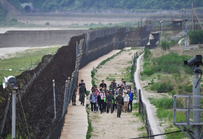
That day is still a long way off, though, judging by the behaviour of the soldiers accompanying us. The dozen or so keeping this flock of civilians moving are not armed, but are watchful. Whenever we stop, they assume a loose perimeter, each man looking outwards – sunglasses beneath the brims of their slouch hats – on the balls of their feet, hands clasped behind their backs.
We follow the path troops use when patrolling this stretch of the South’s defences. To the landward side is a concrete-lined ditch with a fence from which the now familiar “mine” signs hang. On the opposite side are two parallel lines of tall chain-link fences, beyond which is the pristine beach, on to which wavelets wash in from the ocean, driftwood and seaweed marking the tide line. Taped-off pathways mark safe passage through the minefields and a firing range with the black silhouettes of a person wearing a helmet has been staked out on the sand. Powerful searchlights play over the low dunes at night, we’re told.
Butterflies and dragonflies flit on the early summer air as we pass, the waves below a constant rhythmic refrain.
Just in case anyone concludes the mine signs are just for show, a warning – an abandoned excavator – has been left in situ. In 2003, a work detail was digging in an area they believed was free of explosives. The sandy soil here is, however, notorious for shifting and taking mines with it, some of which were laid when the Korean war was raging. The driver of the excavator discovered a mine by driving over and detonating it. No one was injured but the rusting hulk recalls a close shave.
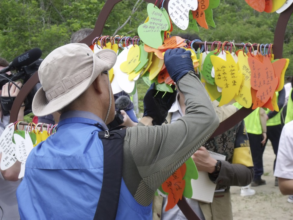
Further on, hikers are encouraged to hang a message on the “Tree of Peace” and ring a peace bell, before the final stretch, which runs parallel to the beach.
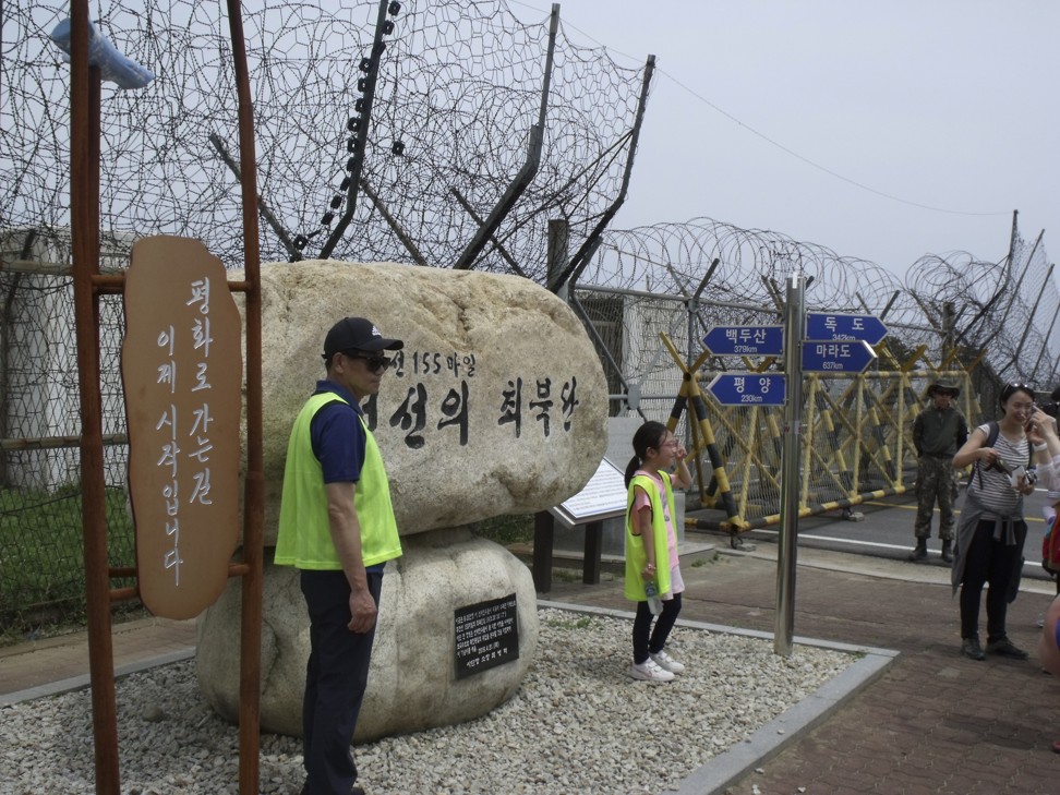
The route ends at a steel gate festooned with barbed wire that blocks the road – 2km from the frontier – as it heads north. Korean hikers have their photos taken in front of a marker placed by President Moon Jae-in that reads, “The road to peace begins here”, the minders careful to make sure no pictures of the gate itself are taken. Beyond the fence, there is no sign of movement. A signpost on the road as it disappears around a bend reads “Pyongyang 230km”.
A bus laid on for hikers takes us up the steep hill to the Geumgangsan Observatory, which has long been open to visitors and where the flags of South Korea and the United Nations fly. A red alarm bell hangs from a stand with a hammer nearby. It may look old-fashioned, but there’s little doubt it would prove effective if it were ever struck. Standing on the top of the last mountain before the peninsula’s rocky spine slopes down towards the ocean, the observatory has an auditorium with floor-to-ceiling windows looking out across the DMZ and into the North.
The guide points out on a scale model what we are looking at: the mountains and lakes of the Mount Kumgang Tourist Region, which was opened in 2002 for South Korean visitors. The sprawling 530 sq km region saw more than 1 million travellers before the programme came to a halt in July 2008, after a tourist was shot dead by a North Korean soldier for entering a restricted area.
Pyongyang is pressing for the visits to Mount Kumgang to resume as a bilateral confidence-building measure but cynics say the regime is more interested in the foreign currency such a move would bring as its economy struggles under international sanctions.
Just 300 metres away from the observatory is Guard Post 829, one of 20 border positions the two governments agreed this year to dismantle as a token of good faith. Before GP 829 could be demolished, however, Seoul declared it a cultural asset – built in 1953, it was the first of its kind – so it will be decommissioned but preserved.
The guide uses his pointer to indicate still-operational military positions across the valley. Looking north from the outdoor deck, observation posts can be seen silhouetted against the sky. I shield by eyes against the sun and try to pick out the guards. I ask one of our minders whether his counterparts in the North are looking at us, too.
“Of course,” he replies.
The new hiking routes are presently open only to South Korean nationals, through a lottery system, although tourism officials anticipate they will be opened to foreign visitors soon.