Graphics: SCMP
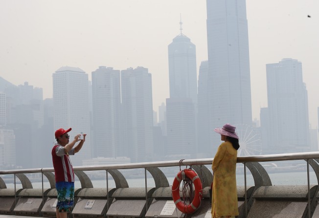
Central, Kwai Chung, Tsuen Wan, Causeway Bay and Mong Kok recorded a “serious” rating, the worst on the air quality health index

Hongkongers are facing poor air and scorching heat ahead of more wet weather as a new typhoon brewing near the Philippines threatens to come within 400km of the city.
On Tuesday the Environmental Protection Department recorded high levels of pollution. Central, Kwai Chung, Tsuen Wan, Causeway Bay and Mong Kok registered a “serious” rating – the worst on the air quality health index.
Temperatures reached over 35 degrees Celsius in parts of the city, with Tseung Kwan O recording a high of 36.2 degrees, according to authorities.
The hot weather was brought about by subsiding air currents from Talim, a storm 750km east-southeast of Taipei, the department said. The resulting intense sunshine had caused high ozone concentrations, and the lack of strong winds meant the pollutants were not being blown away.
The Centre for Health Protection advised the public to keep outdoor activities to a minimum if pollution levels reach a “very high” reading – one level lower than “serious”.
Observatory forecaster Yeung Hon-yin said urban temperatures were expected to reach a maximum of 32 degrees on Wednesday, although the mercury in parts of the New Territories could rise a few notches higher.
Relatively windy weather was expected on Wednesday, he said.
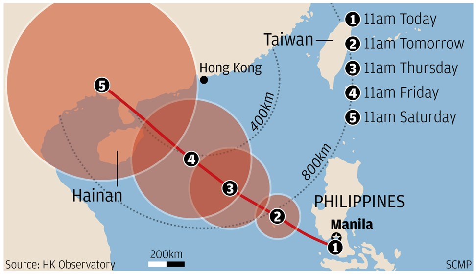
Meanwhile, a tropical depression which is currently centred about 40km away from Manila is expected to intensify, packing winds of up to 120km/h at its centre as it heads towards Hainan Island off the coast of mainland China, according to the Observatory.
It is predicted to strengthen into a typhoon and come within 400km of Hong Kong on Friday.
Yeung said it was difficult to say how serious the storm would be for Hong Kong, although he expected squally showers for the city starting late Thursday and lasting until Saturday.
“It is still a bit early to talk about the signal number,” he said, referring to the city’s warning system for typhoons. “It depends on the track of the storm.”
As for Talim, it is expected to intensify into a super typhoon with wind speeds of more than 185km/h.
Forecasters previously expected it to slam into Taiwan and Zhejiang province, coming within 800km of Hong Kong.
But Yeung said the storm was no longer expected to make landfall, adding that it was now “even further away from Hong Kong”.
Storms are classified as “super typhoons” when average wind speeds over a 10-minute period reach at least 185km/h. Such storms were “not that unusual”, the forecaster said.
Hongkongers have already faced a few weeks of wild weather, after being battered by Typhoon Hato and Severe Tropical Storm Pakhar in August, followed by poor weather from tropical depression Mawar earlier this month.
On Saturday, the Observatory said it was considering whether Hato should be reclassified as a super typhoon. Hato caused 10 deaths and widespread chaos in nearby casino hub Macau while also bringing business and flights in Hong Kong to a standstill.
Observatory director Shun Chi-ming said authorities originally expected to see four to seven tropical cyclones this year, but they had raised the figure to between six and nine.
The increase could be a result of global warming heating up the sea and creating more energy to power typhoons, Shun said.
Additional reporting by Harminder Singh