Source:
https://scmp.com/news/hong-kong/health-environment/article/2164123/why-fuss-over-super-typhoon-mangkhut-how-did-it Health & Environment
Why the fuss over Super Typhoon Mangkhut, how did it get so big and is your weekend ruined? All the things you need to know as Hong Kong prepares for storm
Hongkongers are bracing for what may be most powerful tropical cyclone to hit city. Vegetable prices have shot up and windows are taped. Here is all you need to know.

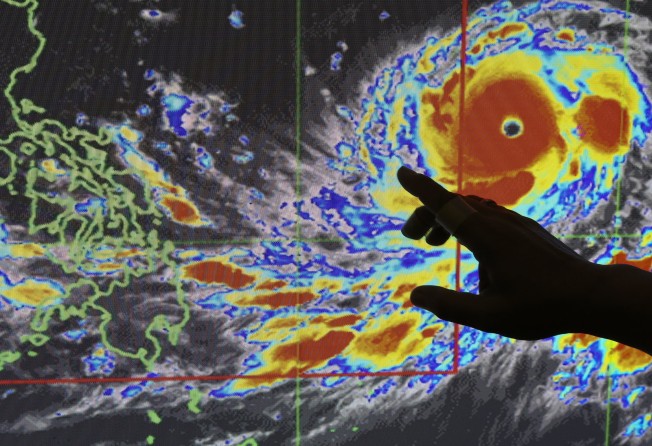
Super Typhoon Mangkhut is on track to be the most powerful storm to hit Hong Kong since records began in 1884. Photo: AP
As Super Typhoon Mangkhut continues to gather strength in the Western Pacific, Hongkongers are bracing for what may be the most powerful tropical cyclone ever to hit the city.
Vegetable prices went up as families stocked up while windows were taped and discussions were had over whether this was even the best practice.
But the jury was still out over whether this would be a direct hit. When it comes to typhoons – at least when they are this far out at sea – size is not always the most important factor. Here’s what you need to know before the storm hits.
We get typhoons every summer, what’s the fuss?
Mangkhut is big. It has a large circulation and is already whipping up intense winds and heavy rain. From what meteorologists can see, the whirling mass of clouds is on track to be the most powerful storm to hit Hong Kong since it began collecting typhoon records in 1946.
With maximum sustained winds of up to 240km/h (149mph) near its centre, this puts it on par with a Category 5 hurricane, the highest on the Saffir-Simpson wind scale for tropical cyclones in the western hemisphere.
It is also expected to come close. According to the Observatory’s current prediction, the tropical cyclone is forecast to pass within 100km of the city as early as Sunday morning. Even if it is not a direct hit, the typhoon could still impact the city adversely, experts say. Its massive rain band is more than 900km wide and could trigger floods and landslides.
Lam Chiu-ying, a former director of the Observatory, said the storm had potential to pose a “great danger to Hong Kong.”
How did it get so powerful?
The storm, named after the Thai word for the mangosteen fruit, was upgraded to a typhoon and later, to a severe typhoon on Monday. It strengthened rapidly and by Tuesday was given the classification of a super typhoon.
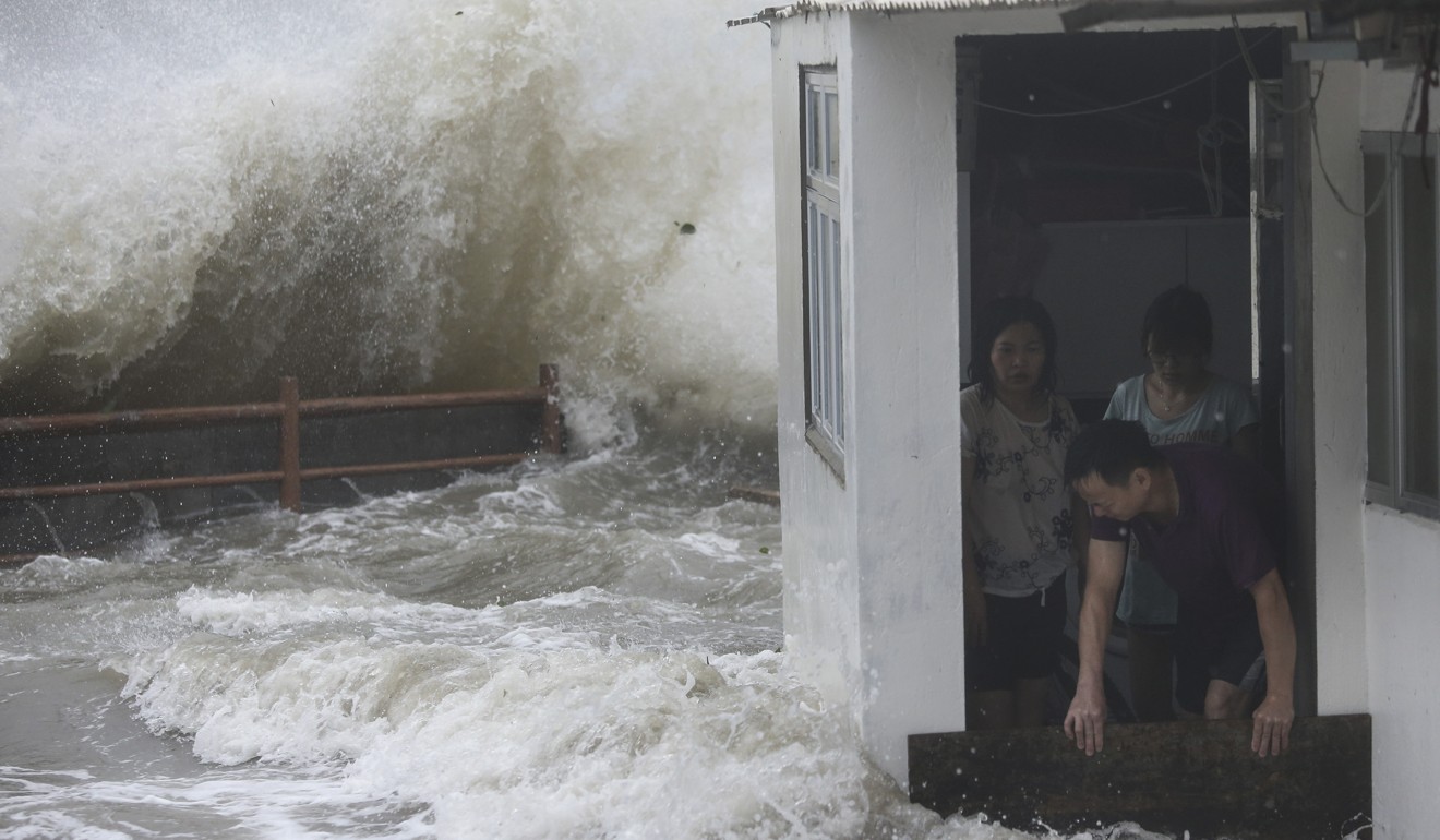
Strong waves hit Lei Yue Mun as Typhoon Hato hits Hong Kong on August 23, 2017. Photo: Sam Tsang
Professor Gabriel Lau Ngar-cheung, an atmospheric scientist at Chinese University, said Mangkhut had all the ingredients of a superstorm.
“Its entire track has been over water and over the warmest seas in the world, in the eastern Philippines,” he said.
The more time a typhoon spends above water, the more energy it sucks in and the stronger it gets. Historically, typhoons that have taken a southwest or south-southwesterly track have been the most intense. Think super typhoons Hato last year, or Wanda in 1962, which killed 130 people and left 72,000 homeless.
Is it at all possible that the storm could change direction?
Yes. As it passes over the narrow Luzon Strait between Taiwan and the Philippines before hitting Hong Kong, it could come across land and mountains. This could take some steam out of it. On Wednesday, the Observatory’s tracking system indicated a 70 per cent probability Mangkhut could deviate within a 500km radius from its predicted position closest to the city, still leaving a lot of uncertainty.
“The recent track of Mangkhut is more westerly than forecast … it may hit Luzon and weaken. While the storm is crossing Luzon, it is possible that it turns even more west,” said Clarence Fong Chi-kong, a meteorologist at the Macau-based ESCAP-WMO Typhoon Committee under the United Nations. “Some storms will recover from the deflection after entering South China Sea, but [others] may not.”
Other than warmer sea temperatures, what other factors could affect a storm’s behaviour?
There’s more to it. The simple way of looking at typhoons is that a warming of ocean waters leads to more evaporation into the atmosphere, which is the main source of energy for typhoons. But atmospheric factors such as the structure of the air circulation around it also play a major role in determining their development.
Sinking air in the upper atmosphere, for example, could put pressure on a typhoon and prevent it from rising and developing. Vertical wind shear at different heights of atmosphere could suppress convection or cause a typhoons cylindrical column to slant, diminishing its strength.
While no single weather event can be attributed to climate change alone, a warmer world effectively turbocharges the intensity of storms giving them more fuel as they move across the ocean. There are natural cycles in typhoon activity, but climate change is also likely to modify these cycles.
So are my weekend plans ruined?
Mangkhut isn’t expected to pass over Luzon and within an 800km radius from Hong Kong – the distance which warrants a No 1 standby signal – until Saturday night.
But Hong Kong will feel the impact of Mangkhut’s extensive circulation earlier than that. According to the Observatory, the weather is expected to deteriorate significantly by the end of the week, with very hot weather forecast for Friday and Saturday, followed by frequent heavy rain, squalls, and rough seas predicted for later this weekend. Seas could swell up and low-lying areas could be hit by storm surges.