Advertisement
Advertisement
Earthquakes
Get more with myNEWS
A personalised news feed of stories that matter to you
Learn more
Geologist Kerry Sieh says Indonesia can expect ‘more of the same, to be perfectly cynical’ in terms of geological activity. Photo: EPA

‘Expect more disasters like Palu’: why giant quakes continue to devastate poorer Asian communities

Former Caltech professor Kerry Sieh expects an even larger one to devastate the archipelago in the next 15 to 20 years. Better education and safety measures could save more lives
Earthquakes

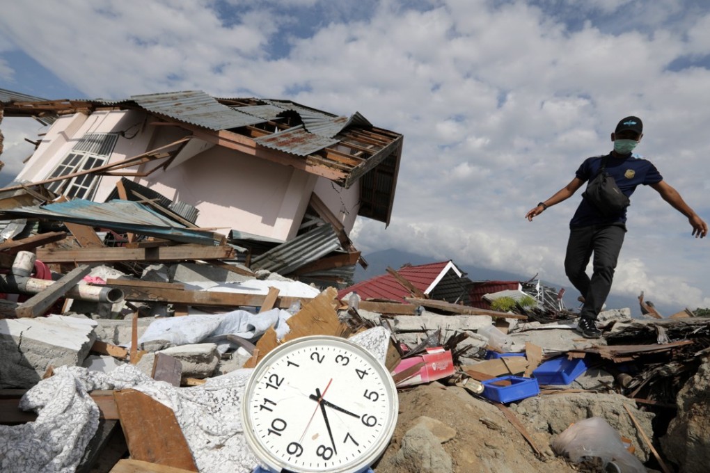
The magnitude-7.5 earthquake and tsunami that hit the Indonesian island of Sulawesi two weeks ago has left more than 2,000 people dead as of Tuesday and the possibility that as many as 5,000 victims have yet to be found, most of them buried in mudflows.

This tragedy is likely to repeat itself, for the archipelago is a hotbed of seismic activity. In the words of one of the world’s leading geologists, Kerry Sieh, Indonesia can “expect more of the same, to be perfectly cynical”.

In particular, Sieh, the director of the Earth Observatory at Singapore’s Nanyang Technological University, has forecast Indonesia’s Sumatra island will be hit by a giant magnitude-9 earthquake in the next 15 to 20 years.

In geology, the places where the earth’s crust has fractured due to the shifting of tectonic plates are known as “faults”, and a 5,500km-long fault called the Sunda megathrust lies to the west of Sumatra – one of Indonesia’s five main islands.

Since the 1990s, Sieh has used corals to build a record of earthquakes in the area over the past 1,000 years, and his research shows major quakes occur every 230 years.

1,600 dead, 70,000 homeless. Why wouldn’t tsunami-hit Indonesia want aid?

“They happen in clusters. So there will be nothing happening for 200 years, and then pop, pop, pop – two or three or more big earthquakes,” Sieh said.

In 2004, a 9.1-magnitude earthquake hit on Boxing Day and launched a tsunami that killed at least 160,000 people in Sumatra’s Aceh province. That quake kicked off the most recent cluster and the fault has experienced two other earthquakes, with just one portion that has yet to “pop”.

“We call this part of it the Mentawai Gap – it’s a gap because it’s a place where an earthquake hasn’t happened yet,” Sieh said.

Geologist Kerry Sieh says the scientific evidence he has collected has not been used to make societies and communities safer. Photo: AP

The Mentawai Gap is located west of Sumatra, running 400km south from the equator – near Padang, the capital of the province, which has a population of 1 million.

In 2008, Sieh, formerly a chaired professor at Caltech, published his paper on the Sunda megathrust. His team has since set up GPS instruments to measure the strain building up along the fault and seismic instruments to monitor any breaks. They have conducted outreach efforts to the nearby communities to warn them about tsunamis and instruct them what to do should one strike.

But communities in the area have implemented few safety measures to prepare for likely disaster.

“In our business, we call this the last mile of the race that was never run,” Sieh said. “The mile of the marathon – between getting scientific evidence collected and interpreted, and doing something with it to make societies and communities safer – never happened.

“Basically, the world is not utilising our information and they are not supporting us enough to collect it much faster, and so we can expect more Palus,” he said.

Rupiah and race: where Indonesian election will be won or lost

The Palu disaster started with an initial 6.1-magnitude quake near the coast of Central Sulawesi, 55km north of Palu, around 3pm on September 28. That was followed by a 7.5-magnitude quake at 6pm that struck further north, triggering a tsunami that rolled into Palu. The earthquake also caused the ground to turn into mud in a process called liquefaction, swallowing entire neighbourhoods.

Almost two weeks later, the dead are still being recovered and rescuers have issued health warnings because of the vast numbers of decomposing bodies they suspect remain buried. Aid has also been slow to arrive because of damaged infrastructure and the limited capacity of Palu’s small airport.

Finger-pointing has been rife. The head of Indonesia’s Meteorology, Climatology and Geophysics Agency was asked to resign amid accusations the agency prematurely lifted the tsunami warning, and numerous reports of tsunami buoys and earthquake sensors not being maintained – with some coverage indicating the buoys had not been operational since 2012. It is also unclear whether tsunami alerts sounded, as the quake took out power and communication networks.

Sieh said the fault that caused the quake had been mapped – by a researcher at the Bandung Institute of Technology, who completed his PhD thesis on the Palu-Koro fault. But no one looked into how often the fault could break, or when the last break occurred.

While a scientist could never be sure when and where an earthquake will strike, it is possible for researchers to identify which faults are under the greatest strain and which ones are poised to release the pressure.

“If the community of geohazard scientists were 10 times larger and 10 times better funded, we’d make 10 times faster progress. But that does not appear to be society’s interest. We scientists don’t do enough to get our stuff out to who matters – people who should be listening to us generally don’t,” said Sieh, who heads the Earth Observatory of Singapore, which devotes 15 per cent of its annual budget to outreach – communicating research to governments, industries, communities and students.

“Parents don’t know if they should ask their schools to teach their children about these things. There’s plenty of blame to go around.”

What could be done

Sieh identified the three separate hazards brought to bear recently on Palu: the earthquake, the tsunami it triggered and the resulting liquefaction.

In other earthquake-prone zones, governments have identified fault lines and bought up nearby land, persuading people to move away, such as in California. In Taiwan, the decision has been that land is too scarce to be left untouched, so it will “let the next generation worry about the damage”, Sieh said.

When three tsunamis hit Hilo in Hawaii in the space of 18 years, the state turned the tsunami-hit shoreline into a park. Aceh province, despite its public mantra to “build back better” watched as wealthier people moved inland but the poor remained near the coast.

As for liquefaction, Alaska experienced it in 1964 when a 9.2-magnitude earthquake turned the ground into quicksand and suburban towns slid into the ocean.

“They’ve turned it into a park called Earthquake Park,” Sieh said.

Bangladesh has a fault under its eastern side that could produce an earthquake bigger than the one that struck Palu. Photo: Agence France-Presse

Different cities have made different decisions depending on their appetite for risk and “their willingness to tolerate three generations down the line being injured by the same thing”, he said. “It’s very difficult to take action to protect yourself or your communities against something that only happens every 100 years.”

Bangladesh, for example, has a fault running under its eastern side that could produce an earthquake exceeding magnitude-8.

“[It could be] many, many, many times bigger than what hit Palu,” Sieh said.

But Dhaka, Chittagong, and Sylhet had done “virtually nothing to ensure the safety of their infrastructure and their populace” he said.

The fact major earthquakes are only expected every 100 or 200 years means there may be a lack of political will for concrete action, so Sieh suggests focusing on education, especially for vulnerable communities.

How to win an election in Indonesia

When the tsunami hit Aceh in 2004, there were disturbing reports of residents running to the beach to inspect the fish left behind when waters receded instead of heading inland to avoid the massive waves that rolled in later.

“Educate them that if you’re on beach or the coast and you feel a strong earthquake, get to high ground as quickly as you can,” Sieh said. “Forget about the hi-tech stuff for the time being. Start with simple education.”

Beyond this, he suggested quake-prone areas have engineers revise building codes to make structures more resistant to quakes, retrofit old buildings, and conduct surveys before construction to discover whether ground is susceptible to liquefaction. Coastal cities could even build tsunami walls or gates that could be closed in 10 minutes to keep waves out. But it is up to communities to run that so-called last mile.

Reflecting on Palu, Sieh said: “Do we bulldoze flat and rebuild, knowing that this earthquake and liquefaction probably won’t happen for a least a couple of hundred years, or do we make a big park that we don’t mind losing in the next earthquake?”

This article appeared in the South China Morning Post print edition as: Palu disaster a harbinger of bigger quake to come
Post