Advertisement
Advertisement
Hong Kong weather
Get more with myNEWS
A personalised news feed of stories that matter to you
Learn more
Spray from Victoria Harbour drenches the Heng Fa Chuen waterfront on Hong Kong Island. Photo: Edmond So

Severe Tropical Storm Ma-on: Hong Kong Observatory to downgrade typhoon warning to No 3 between 9am and 11am, most schools suspended

  • Afternoon primary and secondary schools as well as night schools will resume classes if the signal is lower to No 3 before 10.30am
  • As Ma-on departed, local winds were expected to weaken gradually before noon
This story has been made freely available as a public service to our readers. Please consider supporting SCMP’s journalism by subscribing.

The Hong Kong Observatory will downgrade Severe Tropical Storm Ma-on to No 3 signal between 9am and 11am, leaving all morning and full-day schools suspended on Thursday.

The Education Bureau announced at 5am that classes of all morning and whole-day schools would be suspended on Thursday.

It added that if the No 8 signal was downgraded to No 3 before 10.30am, classes of afternoon primary and secondary schools, and those of evening schools would resume.

Get Thursday updates for storm Ma-On here

The bureau also said classes of all afternoon schools and evening schools will resume if the No 8 signal was replaced by No 1 signal or cancelled by 10.30am.

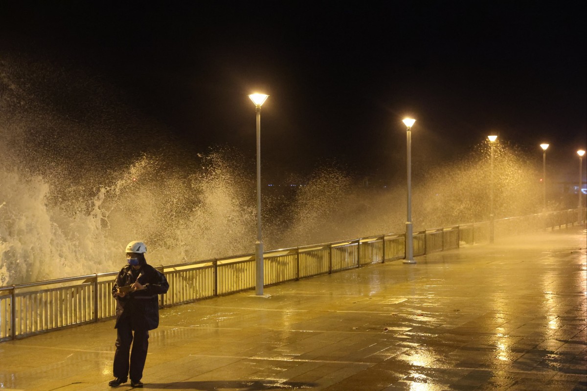
Hong Kong had largely shut down on Wednesday night, with low-lying areas put on flood alert as Severe Tropical Storm Ma-on moved to brush past the city, triggering panic buying that left supermarket shelves empty.

This year’s second No 8 typhoon warning signal was raised at 7.25pm and expected to remain in force until at least 9am the following morning, according to the Observatory.

At 6am on Thursday, Ma-on, which means saddle in Cantonese, was centred about 220km southwest of Hong Kong, with winds hitting a maximum sustained speed of 110km/h near the centre of the weather system.

Gales were affecting many areas while winds at high ground occasionally reached storm force. Showers brought by the storm were also edging closer and could bring violent gusts.

Ma-on moved closest to Hong Kong at 3.45am on Thursday, skirting within 200km south-southwest.

As Ma-on departed, local winds were expected to weaken gradually before noon. The Observatory will assess the need to downgrade the signal to No 3 between 9am and 11am depending on the changes in local winds.

It was forecast to move west-northwest at about 28km/h in the general direction of the coast of western Guangdong.

The No 8 southeast warning signal was issued at 1.40am, replacing the No 8 northeast one from 7.25pm. That meant winds with mean speeds of 63km/h or more were expected from the southeast quarter.

East to southeasterly winds in gale or storm force were forecast for Thursday, but would weaken later. There would be occasional squally showers and thunderstorms, with heavy showers at times, the Observatory said. Seas will be very rough with swells. Temperatures will range between 26 degrees Celsius and 30 degrees.

MTR trains and the Light Rail will operate on Thursday morning at limited frequencies, according to the scheduled time table. MTR Bus service will remain suspended. ​

Residents in Lei Yue Mun preparing for Severe Tropical Storm Ma-on as it edges closer to the city. Photo: K. Y. Cheng

On Wednesday, anxious residents emptied supermarket shelves to stock up ahead of the approaching storm, while those living in coastal flood-prone areas were also sandbagging their homes.

Or Ming-keung, acting senior scientific officer of the Observatory, said on Wednesday afternoon that the outer rainbands associated with Ma-on kept affecting the northern part of the South China Sea and the vicinity of the Pearl River Estuary.

He added that flooding in low-lying areas and seawater intrusion along the coast could occur on Thursday morning due to the storm surge and the current astronomical high tide.

A high water level around three metres (10 feet) above chart datum is expected at Quarry Bay between 5am to 9am on Thursday, according to the Observatory.

Emptied shelves at a supermarket in Wan Chai ahead of the arrival of Severe Tropical Storm Ma-on. Photo: Sam Tsang

The Islands District Office announced that the flood alert system put in place for residents of Tai O village, on Lantau Island, had been activated.

An emergency coordination centre would handle any evacuation, rescue and emergency relief efforts. Residents living in the low-lying areas of Tai O are advised to take shelter before any flooding occurred.

At another black spot, Lei Yue Mun in eastern Kowloon, storekeepers and residents used sandbags as a last line of defence against possible flooding. A seafood restaurant operator said they had put their food in a higher place to minimise possible losses in case of serious flooding.

One restaurant operator said: “That is the best we can do. Let’s leave our fate to God.”

A resident in Lei Yue Mun prepares as Ma-on edges closer. Photo: K. Y. Cheng

Across Victoria Harbour, the property management company of Heng Fa Chuen, a private housing estate in Eastern district prone to flooding, installed barriers on Tuesday, according to lawmaker Edward Leung Hei.

“The home affairs and drainage services departments have also promised to be on full alert and will be monitoring the water level closely,” Leung said, adding that a longer-term solution was to build a higher sea wall.

Heng Fa Chuen was battered by strong winds on Wednesday evening. TV news footage however showed some residents heading to the estate’s promenade to experience the wind and waves.

With Ma-on approaching, the government earlier announced classes at kindergartens as well as schools for children with physical and intellectual disabilities would be suspended. And it later announced that all schools were suspended in the evening.

Pop singer Terence Lam also announced his show on Wednesday evening would be rescheduled to August 28, adding that fans could opt for a refund.

Earlier, residents emptied supermarket shelves as they rushed to stock up on canned foods, instant noodles, meat and vegetables ahead of the storm. Long queues were seen in shops and some had even sold out of fresh vegetables by late morning.

Some residents rushed to supermarkets to stock up on food ahead of the storm, emptying out shelves. Photo: Sam Tsang

A Post visit found that frozen foods and baked goods were out of stock in a number of places. At a supermarket near Hennessy Road in Causeway Bay, shelves for frozen food were almost empty.

Shirley Wong, a housewife in her 60s, said that she was buying extra food in preparation for the storm. “I was afraid there wouldn’t be any shops open tomorrow, so I am buying more for my family,” she said.

John Chan, another resident at the supermarket, said: “The [Observatory] said the storm would hit Hong Kong directly, so probably buying more food is a better option.”

Storm clouds gather above Victoria Harbor in Causeway Bay as Hong Kong upgrades the typhoon warning signal to No 8. Photo: Xiaomei Chen

The Home Affairs Department also opened 31 temporary shelters across the city for people in need. An emergency hotline 2572 8427 has also been set up to answer inquiries. As of 3am, 141 people had sought refuge at the shelters.

The Hong Kong Airport Authority said it had received no report of flight disruptions by Wednesday evening.

As of 2am, there was one report of a fallen tree and one regarding flooding during the storm, according to the government.

Residents enjoy the windy weather at the waterfront in Tsim Sha Tsui. Photo: Sam Tsang

The Hospital Authority said that as of 1.30am one person had been injured during the storm period and received medical treatment at a public hospital.

The No 3 signal was issued at 12.40pm on Wednesday. That followed the No 1 signal on Tuesday night, with the city also waking up to a “very hot weather” warning on Wednesday.

Last month, Hong Kong also issued the No 8 signal as Typhoon Chaba struck the city. Last year, the No 8 signal was issued for Typhoon Kompasu and Tropical Storm Lionrock in October.

The Observatory has estimated five to eight tropical cyclones will come within 500km of the city this year, which is normal to above normal compared with last year.

Additional reporting by Nadia Lam

26